San Joaquin Experimental Range NEON / SJER
Core Terrestrial, CA, D17: Pacific Southwest

About Field Sites
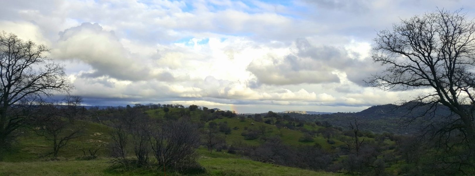
The San Joaquin Experimental range (SJER) is a terrestrial NEON field site located approximately 40 km (25 mi.) north of Fresno, CA. The 18.2 km 2 (4500 acre) site sits at 210-520 m (690-1700 ft.) above sea level in the foothills of the Sierra Nevada mountains and is hosted by the U.S. Forest Service. The area is mainly grassy open oak woodland and drains into the San Joaquin River basin. It is part of the Pacific Southwest Domain (D17), which is bounded by the Pacific Ocean on the west and the Sierra Nevada Mountains on the east, and encompasses most of California. There are four other NEON field sites in D17, including two additional terrestrial sites and two aquatic sites. [1]
SJER has a Mediterranean climate. Winters are cool and wet; the rainy growing season typically runs from October to April, with peak greenness in early March. Summers are hot and dry, with average temperatures between 24-27°C (75-80°F), and high temperatures frequently exceeding 38°C (100°F). Vegetation is mostly dormant during the summer months. Mean annual temperature is 16.4°C (61.5°F). Mean annual precipitation is 539.62 mm (21.25 in.). [1] [11]
The geology of SJER is granodiorite and quartz monzonite. [5]
At SJER parent materials consist of residuum, colluvium, and local alluvium that are derived from Mesozoic aged granite, quartz monzonite, granodiorite, and quartz diorite crystalline rocks. The primary soil series on the site are Ahwahnee (Coarse-loamy, mixed, active, thermic Mollic Haploxeralfs) and Vista (Coarse-loamy, mixed, superactive, thermic Typic Haploxerepts). Both soils are moderately deep to a paralithic contact. [4]
SJER is primarily open oak woodland, with an overstory of evergreen oaks, gray pine, scattered manzanita and whitethorn shrubs. The understory is cool season grasses (predominantly Bromus) with other perennial forbes and legumes. Native bunch grasses can be found on some northern slopes. [1] [3]
A large population of California ground squirrels ( Spermophilus beecheyi ) and other small rodents supports abundant mesocarnivores, including coyotes ( Canis latrans ), American badgers ( Taxidea taxus ), and bobcats ( Lynx rufus ), as well as gopher snakes and rattlesnakes. The site hosts a wide variety of resident and migratory songbird and raptor species, including the important game species California quail ( Callipepla californica ). Species unique to the region include the Western spadefoot toad ( Spea hammondii ), San Joaquin pocket mouse ( Perognathus inoratus ), and Heerman's kangaroo rat ( Dipodomys heermani ). [3]
Past Land Management and Use
The San Joaquin Experimental range was established in 1934 as California's first range research station. Its original research goal was to identify cost-effective methods of livestock production and monitor its effect on the annual grass and oak woodland ecosystem. Research objectives have since expanded to contribute to scientific knowledge of ecological patterns and processes in this ecosystem. In 2009, the Southern Sierra Critical Zone Observatory established an eddy-covariance flux tower on the site to monitor meteorological processes along the critical zone elevation gradient.
The period between 2011 and 2015 marked the driest years on record in California, and significantly reduced the flow of the San Joaquin river. Multiple small wildfires have affected the site and its surroundings in recent years. [2] [6] [7] [8] [9]
Current Land Management and Use
SJER is currently managed in collaboration by the Pacific Southwest Research station of the United States Forest Service and California State University at Fresno's Agricultural foundation. It hosts the university's commercial cow-calf herd. The range serves as an outdoor lab for agriculture students at Fresno State and Fresno City College and is used for extensive ecological and agricultural research. Data collected at San Joaquin forms the basis for over 500 scientific publications in disciplines ranging from livestock production to nutrient flow modeling and fire ecology.
The area immediately surrounding SJER is agricultural, primarily cattle pasture with some wine and fruit production. The site is situated relatively close to two urban areas: the city of Fresno, 32 km (20 mi.) south, and Coarsegold/Oakhurst, 24 km (15 mi.) north. [10]
NEON Site Establishment
NEON plot establishment at SJER began in 2015, and was completed in 2016. The site transitioned to operations in October 2016. The terrestrial sampling and observations began in the same month, coinciding with the start of the central valley’s cool, rainy growing season. Construction of the site’s 39 m (127 ft.), 6-level instrumentation tower was completed in 2017, and the tower came online and began streaming data in the fall of 2018.
Additional Resources
[1] Terrestrial Observation System (TOS) Site Characterization Report: Domain 17. NEON.DOC.003900vB
[2] https://www.fs.fed.us/psw/ef/san_joaquin/documents/SJERannotated_checkl…
[3] Larson, J. H., J. Stebbins, and W. L. Porter. 1985. A revised checklist of plants of the San Joaquin Experimental Range. California State University, Fresno. California Agricultural Technology Institute, CATI Publication 850303. 38 p.
[4] Kunch, Theresa. (2018). NEON Site Level Plot Summary, San Joaquin Experimental Range (SJER), April 2018. https://data.neonscience.org/documents/10179/2361410/SJER_Soil_SiteSumm… .
[5] U.S. Geological Survey, 2005, Mineral Resources Data System: U.S. Geological Survey, Reston, Virginia. https://mrdata.usgs.gov/mrds/
[6] http://criticalzone.org/sierra/infrastructure/field-area/flux-tower-at-…
[7] https://fresnostate.edu/jcast/beef/lab-components/sjer.html
[8] https://www.ppic.org/publication/californias-latest-drought/
[9] https://water.ca.gov/LegacyFiles/waterconditions/docs/California_Signfi…
[10] https://maderacountyedc.com/wp-content/themes/mcedc/ui/images/2014co
[11] PRISM Climate Group., Oregon State University, http://prism.oregonstate.edu , created 4 Feb 2004.
Field Site Information
Latitude/longitude.
37.10878 , -119.73228
Geodetic Datum
Madera County CA, US
Mean: 400m Minimum: 252m Maximum: 502m
Mean Annual Temperature
Dominant wind direction, mean canopy height, dominant nlcd classes.
Evergreen Forest, Grassland/Herbaceous, Shrub/Scrub
Colocated Research
Pacific Southwest Research Station SJER Southern Sierra CZO Critical Zone Exploration Network Ameriflux
Field Operations Office
4727 West Shaw Avenue Fresno, CA 93722
Research Access
Non-NEON research activities are allowed in this area. Researchers must obtain their own permits with the site host(s).
Observation Types
Remote sensing.
Remote sensing surveys of this field site collect lidar, spectrometer and high-resolution RGB camera data.
Meteorological Measurements
This site has a flux/meteorological tower that is 39 m (128 ft) tall with six measurement levels. The tower top extends above the vegetation canopy to allow sensors mounted at the top and along the tower to capture the full profile of atmospheric conditions from the top of the vegetation canopy to the ground. The tower collects physical and chemical properties of atmosphere-related processes, such as humidity, wind, and net ecosystem gas exchange. Precipitation data are collected by a Double Fence Intercomparison Reference (DFIR) near the tower, and a series of throughfalls located in the soil array.
One phenocam is attached to the top and the bottom of the tower. Here we show the images from the most recent hour. The full collection of images can be viewed on the Phenocam Gallery - click on either of the images below.

Tower bottom


Soil Sensor Measurements
This site has five soil plots placed in an array within the airshed of the flux tower. Photosynthetically Active Radiation (PAR) at soil surface, soil heat flux, solar radiation, and throughfall are measured at the soil surface in each soil plot. Soil moisture, soil temperature, and CO2 concentration are measured at multiple depths in each soil plot.
Observational Sampling
At terrestrial sites, field ecologists observe birds and plants, and sample ground beetles, mosquitoes, small mammals, soil microbes, and ticks. Lab analyses are carried out to provide further data on DNA sequences, pathogens, soils, sediments, and biogeochemistry. Learn more about terrestrial observations or explore this site's data products .
Field Site Data
US Forest Service
Site Access Allowed
https://www.fs.fed.us/psw/ef/san_joaquin/
Site Access Details
Researchers should coordinate directly with the US Forest Service for permitting and approval.
Operations Office
Neon field operations office.
Domain 17 Support Facility
NEON Field Operations Address
Neon field operations phone.
559.396.4119
UTM Northing
4110433.94m
UTM Easting
Mean elevation, minimum elevation, maximum elevation, mean annual precipitation, average number of green days, average first greenness increase date, average peak green date, average first greenness decrease date, average minimum greenness date, tower height, number of tower levels, megapit soil family.
Mixed - thermic Psammentic Haploxerolls
Soil Subgroup
Psammentic Haploxerolls
Related Field Sites
Other domain d17 field sites, other field sites in ca.

Hidden Gem: San Joaquin Experimental Range In Collaboration With NEON
by Alyssa Flores | Dec 20, 2021 | News & Events
Have you heard about the San Joaquin Experimental Range otherwise known as SJER?
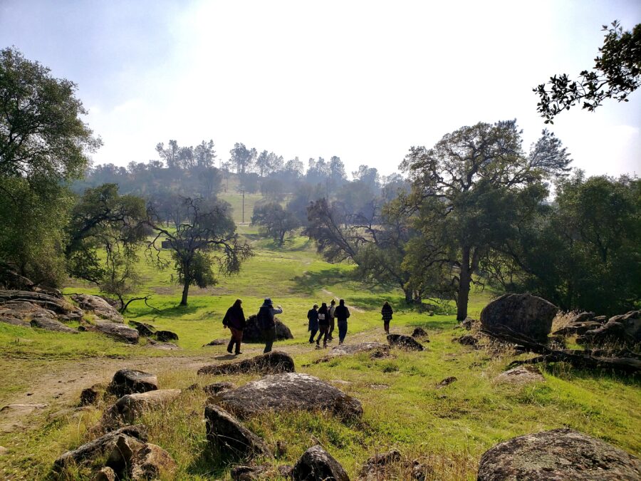
Well, it is a hidden gem located about 25 miles north of Fresno, California. On Wednesday, November 24th, Agriculture and Rangeland Management Supervisor Justin Morgan, District Manager Steve Haze, and I took a site visit to the San Joaquin Experimental Range. Staff from NEON and UCANR welcomed us to a day of exploration and engagement. Rebecca Ozeran a UCCE Livestock & Natural Resources Advisor from UCANR, Erin Crandall a Senior Field Ecologist with NEON, and Sokaina Alkhafaji a Lead Field Technician also with NEON led a productive and insightful tour of the San Joaquin Experimental Range and NEON program.
After a short drive north on Highway 41, there is a blue sign that states “Water 1 mile” and a marker for Rd 406. This is how you know you are approaching the quick turnoff for the entrance of the San Joaquin Experimental Range. Soon after comes the entrance which has another blue sign that states “Water 1/2 mile”. This is your sign to quickly turn off and enter through the gates of the San Joaquin Experimental Range.
Blue “Water 1/2 mile” Sign at the Entrance of the SJER. Image from Google Maps.
Gates at the Entrance of the SJER. Image from Google Maps.
The SJER sits in the foothills of the Sierra Nevada’s in Madera County, spread across 4500 acres of land hosted by the U.S. Forest Service. This land is important because it has a National Ecological Observatory Network (NEON) program that started operations in the Fall of 2018, which runs environmental data collection across the country including Puerto Rico, Hawaii, and Alaska. Over a 30-year time span, NEON in collaboration with the San Joaquin Experimental Range is designed to provide plenty of observational research and data collection that can drive groundbreaking research for years to come.
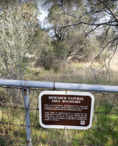
Undisturbed Natural Area Boundary
NEON provides public data that is useful for research spread across multiple subject areas. These areas include agriculture, phenology, ecology, environmental science plus much more. The SJER is also a public site open to new research and data collection upon request and approval from the U.S. Forest service. That opportunity is also open to students who are looking to express their creativity and new innovative ideas on research or data collection in the SJER’s applicable fields of study. As one of NEON’s primary goals is to be an outlet as an educational site and feed the next generation of young scientists.
Located on the San Joaquin Experimental Range, NEON has a data collection tower that is 39 meters high and contains 6 levels. Here, the data is constantly collected, to ensure updated and accurate results. Data collection at the tower includes tree canopy cover, climate, air quality, air pollution, carbon cycling, and soil characteristics. This data can be combined with other data to understand and provide insight into the ecological processes and links between the atmosphere, climate, land use, and species.
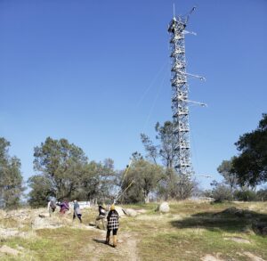
SRCD, UCANR, and NEON Staff
Another great aspect about NEON is its staff. With a warm welcome, the employees are eager to provide insight and encourage new engagements for the SJER. With a young group of leaders at the forefront of a great start to innovative science, it is refreshing to see and experience. NEON offers seasonal positions to get involved and engage in the pivotal work they contribute to every day.
I encourage all to take a visit or check out the opportunities the San Joaquin Experimental Range and NEON program have to offer. There is great potential and capacity for groundbreaking ideas and research to occur in addition to the foundational data collection already in process.
Recent Posts
- New faces at Sierra RCD: Welcoming Climate Action Corps Fellows and Fresno State College Corps students to the team
- CUSP Drought Relief Recipient Highlight
- Sierra RCD Board Member Highlight- Joe Denham
- Women In Wildfire Training
- 2024 Smoke Readiness Webinar Hosted by UCANR Fire Network
Recent Comments
- Craig Jones on Partnering with All Power Labs
- Craig Jones on SRCD Firesafe and Fuels Reduction Team
- News & Events
The District has two primary watersheds, the San Joaquin River and the Kings River, which greatly affect the foothill and valley floor.
Watershed information is available from the State Water Quality Resources Control Board and US Forest Service. Additional watershed/water flow information may be obtained from PG&E and Southern California Edison (power dams and snow packs), and the Bureau of Reclamation (Friant Dam), and the Army Corp of Engineers (Pine Flat Reservoir) and several irrigation districts.
Flooding and soil erosion due to water movement has been a historical problem. The Army Corp of Engineers constructed Francher-Redbank Creek Project, which has reduced the flooding problems on the valley floor.
Flood prone areas are identified in the Flood Hazard Analysis of Northeast Fresno and the more general Flood Hazard Study Maps that are used by the Housing and Urban Development Department.
Canals and irrigation districts on the valley floor provide agricultural water during the dry summer months. Their boundaries and practices can affect the SRCD conservation efforts.
Information on individual and community wells, County Service Area (CSA’s for community water systems), wastewater treatment is available from the Fresno County Environmental Health Department, and the Fresno County Community Development Department.
Groundwater and recharge capabilities of land on the Valley floor and the foothills are an important concern addressed in the Fresno County General Plan. Specifically discussed are the increased pressure on water resources and diminishing capacity for recharge caused by conversion of agricultural and rangeland to other uses.

San Joaquin Experimental Range
In association with the Southern Sierra CZO, the San Joaquin Experimental Range is part of an elevational transect that increases in altitude from west to east: SJER (400 m), Soaproot Saddle (1100 m), Providence Creek Headwater Catchments (P301, 2000 m), and Short Hair Creek (2700 m).
The San Joaquin Experimental Range (SJER) was established in 1934 and was California's first range research station. It was originally conceived as a cooperative interdisciplinary research center to identify cost-effect methods of commercial livestock production in the annual grass-oak pine woodlands, while maintaining the integrity of the ecosystem. More recently, research objectives have expanded and diversified to include research projects making contributions to our knowledge of the patterns and processes working in this ecosystem.

Located near the geographic center of California in the western foothills of the Sierra Nevada, the SJER is the core site for the Pacific Southwest.
NEON data (core terrestrial) from this site.

IMAGES
VIDEO
COMMENTS
The science focus for the Pacific Southwest is on a climate gradient, extending from the core site in the oak woodland at the San Joaquin Experimental Range, up through an elevation gradient into mixed conifer and red fir forests.
The San Joaquin Experimental range (SJER) is a terrestrial NEON field site located approximately 40 km (25 mi.) north of Fresno, CA. The 18.2 km 2 (4500 acre) site sits at 210-520 m (690-1700 ft.) above sea level in the foothills of the Sierra Nevada mountains and is hosted by the U.S. Forest Service. The area is mainly grassy open oak woodland ...
The San Joaquin Experimental Range is an ecosystem research experimental area in the foothills of the Sierra Nevada. The range is located in O'Neals, California , outside of the Sierra National Forest about 32 kilometres north of Fresno, California .
Jared Verner. Sylvia R. Mori. We examined population trends and factors related to the abundance and presence of European starlings (Sturnus vulgaris) at the San Joaquin Experimental Range...
Download scientific diagram | Map of the San Joaquin Experimental Range (SJER) with location of study regions in California (left panel) and discrete-return LiDAR point image with terrain...
You can use this list of landmarks to find the CSUFresno San Joaquin Experimental Range. See also the accompanying map. The Range is about a half-hour drive from Fresno. You will be in rush hour traffic, so be careful and plan ahead. See your lab schedule for the time and dates to meet at the Range.
Over a 30-year time span, NEON in collaboration with the San Joaquin Experimental Range is designed to provide plenty of observational research and data collection that can drive groundbreaking research for years to come.
The San Joaquin Experimental Range (SJER) is an ecosystem research experimental area in the foothills of the Sierra Nevada (MLRA 18). The range is located near O'Neals, California, outside of the Sierra National Forest and about 32 kilometers (20 miles) north of Fresno, California. The San Joaquin Experimental Range was established in 1934.
In association with the Southern Sierra CZO, the San Joaquin Experimental Range is part of an elevational transect that increases in altitude from west to east: SJER (400 m), Soaproot Saddle (1100 m), Providence Creek Headwater Catchments (P301, 2000 m), and Short Hair Creek (2700 m).
The San Joaquin Experimental Range is an ecosystem research experimental area in the foothills of the Sierra Nevada. [1] The range is located in O'Neals, California, outside of the Sierra National Forest about 32 kilometres north of Fresno, California.